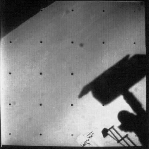
This JPL information sheet illustrates how Surveyor III landed.
Preserved by Les Whaley. Scan by Colin Mackellar.
Surveyor 3
by Hamish Lindsay.
Surveyor 3.
Launched : 0705 UT (1705 AEST) Monday 17 April 1967.
Landed : 0004:17 UT (1004:17 AEST) Thursday 20 April 1967.
Located : Lat: 3.33°S by Long: 23.17°W in Mare Insularum in Oceanus Procellarum.
Final LOS : Thursday 0004 UT (1004 AEST) 4 May 1967.
Final attempts to contact spacecraft, mission terminated : 2 June 1967.
The specific objectives for this third mission were to:
(1) Perform a soft landing on the Moon within the Apollo zone and east of the Surveyor 1 landing site.
(2) Obtain post landing television pictures of the lunar surface.
(3) Obtain information on lunar-surface bearing strength, radar reflectivity, and thermal properties.
(4) Use the surface sampler to manipulate the lunar surface and observe the effects with the television camera.
Prime tracking mission support was provided by Deep Space Network using DSS-11 (Goldstone, California), DSS-42 (Tidbinbilla, Australia) and DSS-61 (Madrid, Spain) to provide tracking data, telemetry, video and command functions.
Additional support was provided by the Air Force Eastern Test Range stations during the launch phase, DSS-71 (Cape Kennedy), DSS-72 (Ascension Island), DSS-51 (Johannesburg) and DSS-12 (Goldstone). Manned Space Flight Network (MSFN) support was by Bermuda, Tananarive, Carnarvon and Goddard Space Flight Center (GSFC).
Launch.
April 17 was considered the most suitable date to launch Surveyor 3 because landing could be achieved early in the lunar day with low Sun angles at the landing site, highly desirable to enhance photography.
Surveyor 3 was launched at 07:05:01 UT (1705:01 AEST) on 17 April 1967 on an Atlas-Centaur D AC-12 from Launch Complex 36B of the Eastern Test Range at Kennedy Space Center on a launch azimuth of 100.81º. Unlike Surveyors 1 and 2, after separation 3 minutes 59 seconds after lift-off at 07:09:00 UT (1709:00 AEST) from the Atlas, the Centaur burned for 5 minutes 40.5 seconds, putting the spacecraft into a 170.3 by 159.3 kilometre Earth parking orbit with a period of 87.7 minutes. By now the Centaur could perform multiple burnings.
Deep Space Station 42 at Tidbinbilla was designated as the first 2-way acquisition station, and was also called on to process the real-time telemetry received by the Manned Space Flight Station at Carnarvon in Western Australia. It was thought Carnarvon could have bridged the gap between the Air Force Eastern Test Range tracking and the Deep Space Station acquisition at DSS42. A new system using a Bell Modem transmitted the 550 bits/second real time telemetry data from Carnarvon through Tidbinbilla to Mission Control, which extended Tidbinbilla’s coverage by 10 minutes 49 seconds. Initial acquisition by DSS42 (Tidbinbilla) was at 07:55:42 UT (1755:42 AEST) with two-way tracking at 08:01:50 UT (1801:50 AEST).
Carnarvon acquired the spacecraft at 07:48:01 UT (1748:01 AEST) but experienced poor telemetry signal quality due to the extreme range, and heavy interference in the telemetry channels due to local airport distance measuring equipment signals, though the C-Band radar provided 68 minutes 20 seconds of beacon tracking data.
Flight.
After a 22 minute 7.6 second coast, at 7:36:58 UT (1736:58 AEST) the Centaur’s second burn of 1 minute 51.3 seconds injected the spacecraft into a selenographic trajectory and dropped clear at 07:39:54 UT (1739:54 AEST).
At 07:48 UT (1748 AEST) the solar panel was deployed and Sun acquisition took about 7 minutes. Next, at 16:27:51 UT (0227:51 AEST on 18 April), the guiding star Canopus was located. This was the first time Canopus was found automatically – previously the star’s intensity signal was greater than the automatic lock threshold, preventing automatic acquisition.
A midcourse manoeuvre at 04:57:24 UT (1457:24 AEST) on 18 April with a burn time of 4.278 seconds, aimed Surveyor 3 closer towards the selected landing point. The original aim point was within a 30 kilometre circle (previous targets were within a 50 kilometre circle), but with the small midcourse correction required and the high quality of the tracking data, the target was planned within an ellipse of 15.1 by 10.6 kilometres.
Landing.
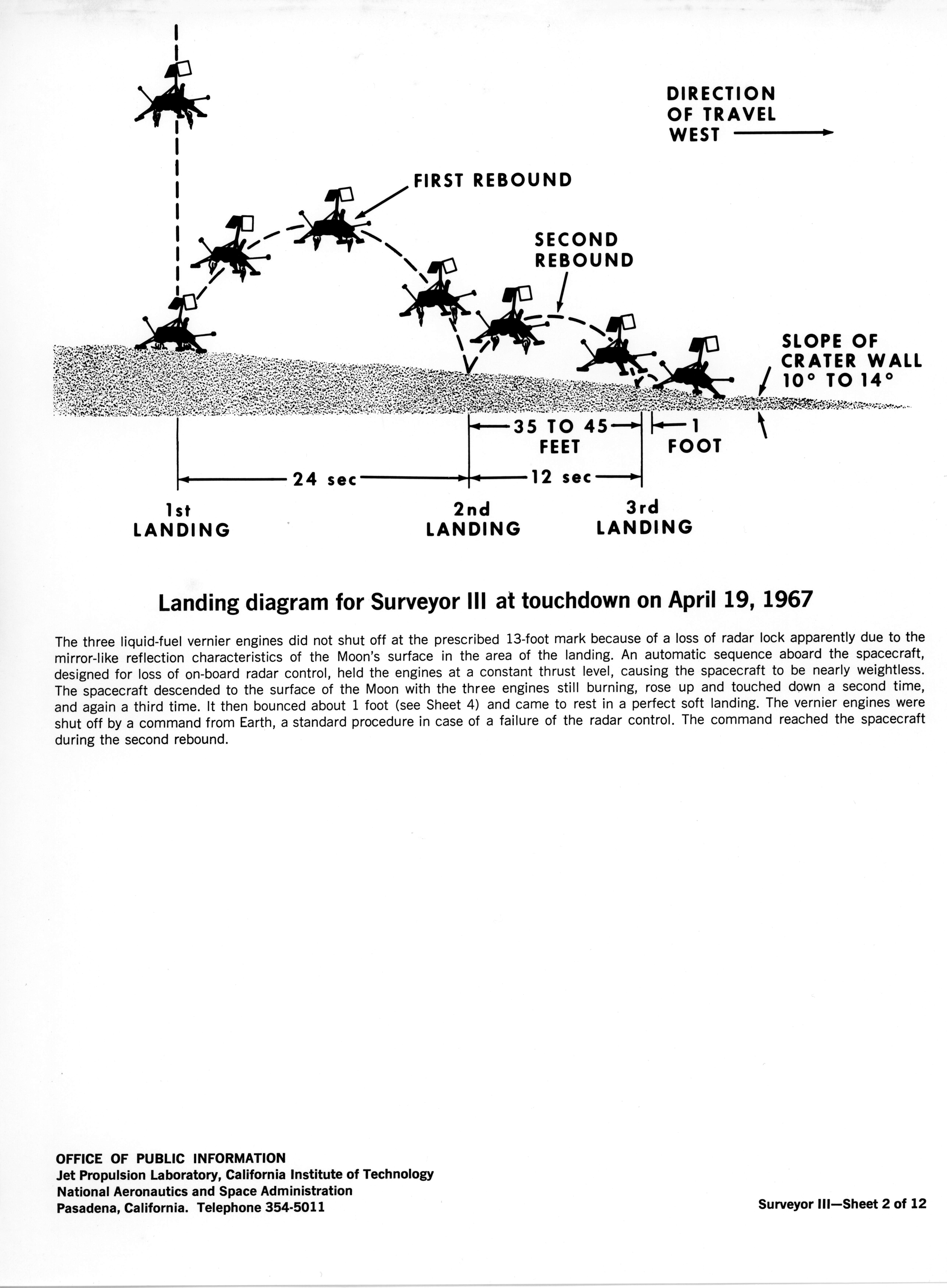
On 20 April at 00:01:16 UT (1001:16 AEST), at an altitude of 76 kilometres above the Moon, travelling at 9,453.6 kph, the vernier and main retro rockets were ignited by a signal from the altitude marking radar, slowing the spacecraft to 493.2 kph at the time of retro burnout and ejection. Descent continued under control of the vernier engines and the Doppler and Altimeter radar.
Two radar systems were used during the terminal descent phase: an Altitude Marking Radar (AMR) and a Radar Altimeter and Doppler Velocity Sensor (RADVS). A few seconds before touchdown the radars lost lock, apparently due to high scintillating reflections from the landing site. The spacecraft guidance system automatically switched to an inertially controlled mode, which prevented vernier engine cutoff.
Touchdown on the lunar surface occurred three times because the vernier engines continued to fire during the first two touchdowns causing the spacecraft to lift off the surface. The distance between the first and second touchdown sites was about 20 meters, and between the second and third 11 meters in a westerly direction.
|
This JPL information sheet illustrates how Surveyor III landed. Preserved by Les Whaley. Scan by Colin Mackellar. |
Engines were shut off 34 seconds after initial touchdown by an engine cutoff command transmitted from Earth. Initial touchdown occurred at 00:04:16.9 UT (1004:17 AEST), 64 hours 9 minutes 16 seconds after lift-off. The third and final touchdown was at 00:04:53.2 UT (1004:53 AEST) on 20 April 1967 at Latitude 3.33°S, Longitude 23.17°W, 2.76 kilometres from the target and 625 kilometres to the west of Surveyor 1. The spacecraft slid about 30 centimetres following the final touchdown. Surveyor 3 came to rest on a 14° slope inside a subdued 200 meter wide crater in southeast Oceanus Procellarum roughly 370 kilometres south of Copernicus Crater.
As they were not sure of the exact spot Surveyor 3 had landed, Ewen Whitaker of the University of Arizona, studied pictures of the inside of the crater and tried to match it with details of a Lunar Orbiter picture, until he eventually found a crater that matched, and the exact location of the spacecraft was determined. This allowed Apollo 12 to zero in to a pin-point landing only 183 metres away.
Remember, only five years earlier, the Americans had so much anguish just hitting anywhere on the Moon!
Lunar Surface Activities.
After landing there appeared to be an acute power system problem, but following investigations it was determined that the power system was normal, and the problem was confined to the signal processing system. Once settled, the spacecraft aligned the antenna to Earth and switched to high power. The signal level at Goldstone increased to -98 dbm and the data rate increased to 4400 bits per second. The spacecraft was ready to send pictures at 08:38 UT (1838 AEST). The first 600-line pictures of the spacecraft and a panorama were transmitted 2 minutes 36 seconds later.
Surveyor operated throughout the lunar day until after local sunset on 3 May.
The trench digger began operations on 21 April over Goldstone with a bearing test. Able to reach out to 1.5 metres, it operated for a total of 18 hours 22 minutes, digging trenches as deep as 17.5 centimetres and dumping soil samples in front of the television camera for inspection. The sampler performed 8 bearing tests, 4 trench tests and 14 impact tests, plus soil samples were moved to desired locations.
The first digger operator, engineer Floyd Roberson, said he developed a feel for the lunar soil through the scoop, and compared his vantage point to that of a near-sighted person viewing the soil from 1.2 metres away. He could feel the increase in resistance about a centimetre below the surface that the Apollo astronauts later reported.
From the results, scientists decided that the lunar soil was like wet sand, with a load bearing capacity of 0.7 kilograms per square centimetre – solid enough to bear the weight of an Apollo lunar module. Once the scoop dropped a shovelful of Moon dirt on one of the footpads, to be found later, undisturbed, by the Apollo 12 astronauts.
The television camera returned 6326 pictures during the first day. A large volume of new data on the strength, texture, and structure of lunar material was transmitted by the spacecraft. Images of an eclipse of the Sun by the Earth and related thermal measurements were recorded. Excessive glare in some of the images was attributed to dust or erosion effects on the mirror due to the extended operation of the engines during touchdown.
DSS-42 Tidbinbilla supported 17 passes of Surveyor 3 during the first lunar day.
The last data for the first lunar day was returned on 4 May 1967 at 00:04 UT (1004 AEST) and Surveyor 3 was put into a configuration that was regarded as optimum for survival of the night. This final command was sent from DSS-42, Tidbinbilla.
With the dark, the temperature rapidly dropped to -18ºC. The solar panel had been positioned to provide power at dawn, and the battery energy had been conserved so that going into the night it was almost fully charged. The spacecraft should have been in good shape ready for more work the next lunar day.
On 23 May at 20:52 UT (0652 AEST 24 May) DSS-61 (Madrid) tried to contact the spacecraft but failed to receive any signal. Attempts by DSS-11 (California), DSS-61 (Madrid) and DSS-42 (Tidbinbilla) all failed to wake the spacecraft up. A final attempt by DSS11 on 2 June also received no response so the mission was terminated.
Despite the shorter experiment time, all Surveyor 3 mission objectives were accomplished.
Apollo 12
On 19 November 1969 the Apollo 12 Lunar Module landed within 183 metres of the Surveyor 3 spacecraft. Astronauts Pete Conrad and Alan Bean visited the spacecraft on their second moonwalk at 06:15 UT (1615 AEST) on 20 November 1969, examining Surveyor 3 and its surroundings, taking photographs, and removing about 10 kg of parts from the spacecraft, including the TV camera, for later examination back on Earth. They also collected some of the rocks and soil around the Surveyor.
Mission Commander Pete Conrad spoke about the visit,
“The Surveyor was coated with a coating of fine dust, and it looked tan, or even brown in the lunar light, instead of the glistening white that it was when it left Earth. It was decided later that the dust was kicked up by our descent onto the surface, even though we were 183 metres away.
We cut samples of the aluminium tubing, which seemed more brittle than the same material on Earth, and some electrical cables. Their insulation seemed to have gotten dry, hard, and brittle. We managed to break off a piece of glass, and we unbolted the TV camera. Then Al suggested we cut off and take back the sampling scoop, and so we added that to the collection."
The Surveyor 3 camera is now on display in the Smithsonian National Air and Space Museum in Washington, D.C.
_______
See also:
Surveyor 3 images, scanned by Keith Aldworth.
The Missions: Surveyor 1, Surveyor 2, Surveyor 3, Surveyor 4, Surveyor 5, Surveyor 6, Surveyor 7.
Surveyor Program Results Summary, The Surveyor Spacecraft and Systems.