Surveyor 1’s flight trajectory, compared with predictions.
Surveyor 1
by Hamish Lindsay.
Surveyor 1.
Launched : 1441:01 UT Monday 30 May 1966 (0041:01 AEST Tuesday 31 May)
Landed : 0617:36 UT (1617:36 AEST) Thursday 2 June 1966
Location : Lat: 2.41°S by Long: 43.43°W in crater Flamsteed P in Oceanus Procellarum.
Final LOS : Wednesday 0730 UT (1730 AEST) 13 July 1966
Mission terminated : Saturday 7 January 1967
The primary objectives of the first Surveyor mission were to:
(1) Demonstrate the capability of the Surveyor spacecraft to perform successful midcourse and terminal maneuvers, and to achieve a soft landing on the Moon.
(2) Demonstrate the capability of the Surveyor communications system and the Deep Space Network (DSN) to maintain communications with the spacecraft during its flight and after a soft landing.
(3) Demonstrate the capability of the Atlas/Centaur launch vehicle to inject the Surveyor spacecraft on a lunar intercept trajectory.
Secondary objectives were to:
(1) Obtain in-flight engineering data on all spacecraft subsystems used during the cruise phase.
(2) Obtain in-flight engineering data on all subsystems used during the mid-course manoeuvre.
(3) Obtain in-flight engineering data on the performance of the closed loop terminal descent guidance and control system which included the velocity and altitude radars, the on-board analog computer, the auto-pilot and the vernier engines.
(4) Obtain engineering data on the performance of the sub-systems used on the lunar surface.
Tertiary objectives were to:
(1) Obtain post landing TV pictures of a spacecraft footpad and the surface material immediately surrounding it.
(2) Obtain post landing pictures of the local topography.
(3) Obtain data on the reflectivity of the lunar surface.
(4) Obtain data on the bearing strength of the lunar surface.
(5) Obtain temperature data of the spacecraft and lunar surface.
Surveyor 1 had over a 100 engineering sensors, including resistance thermometers, voltage sensors, strain gauges, accelerometers, position indicators and other such devices. The fact these were engineering devices, not scientific instruments (except perhaps the imaging system), highlights this mission was only an engineering exercise to successfully soft land on the Moon.
Prime support tracking stations for the mission were Deep Space Station 11 (Goldstone, California), DSS51 (Johannesburg, South Africa) and DSS42 Tidbinbilla (Canberra, Australia) to provide tracking data, telemetry, video and command functions.
Central Mission Control, the Space Flight Operations Facility (SFOF), was located at the Jet Propulsion Laboratory (JPL) in Pasadena, California. More than 100,000 commands were issued from the SFOF to the spacecraft during the life of the mission.
When Bob Roderick, the Hughes Project Manager, was asked what were the chances of success, he answered, “A thousand to one.”
Launch.
Just four months after the Russian Luna 9 sent the first pictures of the surface of the Moon, the Surveyor 1 spacecraft was launched one second late on 30 May 1966 at 14:41:01 UT (0041:01 AEST 31 May) on an Atlas/Centaur D AC-10 booster from Launch Complex 36-A of the Eastern Test Range to an altitude of 192.6 kilometres (104 nautical miles), when the Centaur’s engines were fired for 7 minutes 14 seconds to send the spacecraft directly into a lunar impact trajectory. At that time the Centaur rocket was incapable of multiple firings to use Earth parking orbits.
Flight.
A plethora of tracking stations locked on to Surveyor 1’s signal in the post launch period – Cape Kennedy, Grand Bahama, Grand Turk, Antigua, Ascension and Pretoria were joined by the Manned Space Flight Network at Grand Canary, Bermuda, Kano, Tananarive, and Carnarvon, plus 3 tracking ships.
Shortly after booster cutoff, the internal programmer commanded extension of Surveyor's legs and two omni-directional antennas, and turned the spacecraft's transmitter to high power. The programmer then initiated separation of Surveyor from the Centaur booster.
Five seconds later the Centaur was rotated 180 degrees by its attitude control system in order to perform a retro-manoeuvre to ensure that sunlight reflected from Centaur would not confuse Surveyor’s optical sensors, and to prevent the Centaur from impacting the Moon. The spacecraft also gave a command to fire explosive bolts to unlock the solar panel. A stepping motor aligned the panel to a pre-determined position ready to look for the Sun. Surveyor then performed an automatic Sun-seeking manoeuvre to stabilise the pitch and yaw axes, and to align its solar panel with the Sun.
Next the spacecraft went searching for a signal from DSS-51, the Johannesburg tracking station in South Africa, its first point of contact with Earth. Once locked on, the flight controllers could determine the status of the spacecraft and issue commands. The only hitch was one of the two low gain omni-directional antennas, Antenna A, did not deploy. It seemed the problem solved itself after the spacecraft landed when it was found the antenna must have deployed itself during the jolt of either retrofire or landing.
|
Surveyor 1’s flight trajectory, compared with predictions. from a Hughes publication – courtesy Ken Nelson (Hughes Manager of Station Operations). |
During the flight, the estimated error circle for the landing point was reduced to 60 kilometres, so the aim was adjusted slightly northward for the mid-course manoeuvre, bringing the target area away from Flamsteed itself, and into the northern half of the 100 kilometre crater. After a midcourse correction using the autopilot and vernier propulsion system at 06:45 UT (1645 AEST) on 31 May, the spacecraft reached the Moon 63 hours 30 minutes after launch.
Landing.
Upon arrival above the lunar surface, the Terminal Descent phase began at a height of 1,850 kilometres with a pre-retro manoeuvre 30 minutes before landing. Next the altitude radar was activated 370 kilometres (200 nautical miles) above the surface and subsequent events were controlled by the Radar/Doppler Velocity Sensor and Flight Control Programmer. The auxiliary battery was connected to assist the main battery cope with the extra power demands of the landing sequence.
At 110 kilometres (60 nautical miles) slant range the radar started the Flight Control Programmer, which started counting down. At this point the spacecraft was travelling at 6,000 miles (11,100 kilometres) per hour. Then, at an altitude of 95.5 kilometres, a command from DSS11 (Goldstone) modified the spacecraft’s attitude to align the main retro-rocket to face the flight path. The gas jets fired to break the spacecraft away from tracking the Sun and the guiding star Canopus, and to execute the required roll, pitch and yaw to align the main retro engine to face the flight path. Attitude was maintained using inertial sensors and gyros.
At an altitude of 75.3 kilometres and a velocity of 9,403 kph, the main retrorocket, signalled by the altitude marking radar, ignited for a 40 second burn and was jettisoned at an altitude of about 11 kilometres, having slowed the spacecraft to 396 kph. Descent continued with the vernier engines under control of the altimeter and Doppler radars. Twelve seconds after the burn the main retro-rocket casing was cast off with explosive bolts and fell away free.
The descent was now under control of the radar and three vernier engines, and the rate of descent was further slowed until the spacecraft was about 4.3 metres above the surface when the engines cut, and Surveyor 1 dropped to the lunar surface at about 10.8 kph – hopefully not on a large boulder, or the steep side of a crater, as there was no human pilot to avoid visible ground obstacles!
Surveyor 1 landed at 06:17:36 UT (1617:36 AEST) on 2 June, 1966, at Latitude 2.41°S, Longitude 43.43°W, about 14.5 kilometres from the final planned target.
The momentous moment was announced by Dr Albert Hibbs (the voice of JPL) with,
“…… one hundred feet …… thirteen feet per second…… TOUCHDOWN!!” and pandemonium broke out in the mission control room with papers flung in the air to flutter down over the cheering, hugging flight controllers.
The spacecraft found it had chosen a dark (estimated albedo of 0.052), smooth, bare surface encircled by hills and low mountains inside an unnamed 100 kilometre wide crater filled with mare material, north of Flamsteed Crater in southwest Oceanus Procellarum. The general slope of the landing site was less than 3°.
This area was chosen as a landing site because:
(1) From Earth based observation it appeared to be relatively flat; contained few visible craters or rills and showed little coverage by rays.
(2) It was near the point of vertical descent for Surveyor trajectories.
(3) It was within the landing zone of interest for Apollo landings.
(4) The Sun was fairly low over this area at the expected time of landing.
As Surveyor 1 was about to land, an anxious group of executive level people were gathered around the Control Center at the Jet Propulsion Laboratory. Among them was Congressman Joseph Karth, a strong supporter of the program. He was acutely aware that there was every chance of a failure with such a complex mission. It was reported that his grin lit up the whole darkened area when the spacecraft touched down to a flawless landing.
Lunar Surface Activities.
Surveyor 1’s first hour on the Moon was spent performing engineering tests, after which photography sessions were initiated at 06:53 UT (1653 AEST) with a 200-line picture through an omni-directional antenna.
After 14 pictures were taken, the imaging system was switched over to the higher resolution 600-line system. To everyone’s relief the first pictures showed the footpads only made slight depressions in the lunar soil, from 3 to 8 centimetres deep, confirming it would support a spacecraft.
The television system transmitted pictures of the spacecraft footpad and surrounding lunar terrain and surface materials. Though colour pictures were taken using filters, no colour was seen in the lunarscape.
Panoramic mosaics compiled from many of the frames eventually showed almost the entire landing region with details down to 2 millimetres.
The pictures showed the terrain within 1 to 2 kilometres surrounding the site was a gently rolling surface studded with craters with diameters from a few centimetres to several hundred metres, littered with fragmented debris ranging in size from millimetres to more than a metre. Some 10,338 high-resolution photographs were returned prior to lunar nightfall on 14 June. Most of the pictures were commanded and recorded by the Goldstone Tracking Station when Surveyor 1 took the first 144 images. Some of the images originated from the DSS-42 station at Canberra.
The images observed during the first day ranged through Sun angles of 28° to 88°.
Only 23 images were taken in the 200-line mode – the rest were in the 600-line mode. No pictures were taken during the early afternoon because temperatures were too high for camera operation. The camera resumed operation when the Sun reached an elevation of 78° and continued until after sunset. Only 821 pictures were taken during the afternoon of the second lunar day with Sun angles ranging from 0.5° to 20°.
A scan conversion system at JPL made it possible to display the Surveyor pictures in real time on standard television monitors at the Laboratory as they were relayed from the Moon through the Goldstone Tracking Station. Commercial television networks were able to broadcast the live pictures throughout the nation, while the Early-Bird Satellite relayed the pictures to Europe.
The spacecraft also acquired data on the radar reflectivity of the lunar surface, bearing strength of the lunar surface, and spacecraft temperatures for use in the analysis of the lunar surface temperatures. At high noon on the Moon the temperature reached 121°C (250°F).
After the first lunar sunset at 16:18 UT 14 June (0218 AEST 15 June), the camera was aimed at where the Sun had just sunk below the horizon and pictures were taken of the solar corona. Surveyor took its final image for the day at 16:37 UT (0237 AEST 15 June), a 4-minute exposure of footpad No 2 lit only by earthshine – the Sun’s light reflected off the Earth.
Engineering interrogations continued on 15 and 16 July until a final command for the lunar day was sent to the spacecraft at 20:31 UT 16 June (0631 AEST on 17 June) to terminate telemetry transmissions. Only the two receivers and command decoder were left on. These were needed to wake the spacecraft up the next lunar day.
On 28 June, a few hours before sunrise of the second day, commands were transmitted from DSS-11, Goldstone, to turn the spacecraft transmitter on, but there was no response. For several hours that day DSS11 repeated the command.
Then, beginning on 3 July, the task was transferred to DSS-42, Tidbinbilla. Finally, 3 Earth days later, at 11:29 UT (2129 AEST) Surveyor 1 responded, but it was noted the battery voltage was low, so the first priority was to charge the battery.
On 7 July the camera was commanded on, and 24 images were received, which proved the camera was operational, but there was still a problem with the battery with a rapidly rising temperature. The solar panel was adjusted to reduce the charging rate, but the temperature continued to rise. Believing they may lose contact with the spacecraft, 38 x 600-line pictures were taken while still in view of DSS-42 (Tidbinbilla).
Commands were also transmitted from DSS-42 to turn the Approach Camera on (not used for the landing). Unfortunately no images were received though telemetry indicated the camera was operational.
The battery temperature climbed to 59.9°C during 8 July, then began dropping, and by the next day was back to normal. The solar panel was then adjusted in slow steps until the full charging rate was restored. Though the battery problem was never resolved, normal spacecraft operations resumed on 12 July.
Among the pictures received that day was a survey of the top of the spacecraft Compartment A, revealing for the first time damage to the glass thermal control surface. As the Sun headed for the western horizon, all three prime tracking stations took pictures to record the spacecraft’s shadow as it advanced across the lunar landscape. As the last pictures were taken by DSS-51, Johannesburg, just before sunset during 14 July, the high gain antenna was aligned vertically, requiring the television mode to change down to the 200-line mode for the final pictures.
As the final sunset pictures were being taken by DSS-51, another attempt was tried to observe the solar corona, but suddenly the telemetry indicated a large battery voltage drop. As a result DSS-51 experienced total loss of signal at 03:00 UT (1300 AEST) before the solar corona images could be exposed. As there was no further contact with the spacecraft, further efforts were abandoned when DSS-51’s view period ended.
On 13 July at 07:30 UT (1730 AEST), 1966, after a total of 11,240 high resolution images had been transmitted, Surveyor 1's mission was terminated. Engineering interrogations continued until 7 January, 1967.
All the Surveyor 1 mission objectives were accomplished.
At Deep Space Station 42, Tidbinbilla, Canberra, Australia.
At DSS42, no chances were taken. All vehicles were forbidden to come within 1.6 kilometres of the station and its 26 metre dish antenna for 2¼ hours in case of electrical interference – even the cooking ovens were turned off and station staff had to wait until the critical tracking period was over before they could enjoy hot food again.
Technician Les Whaley kept a list of the Hughes Operational Team and the DSS42 station personnel who were assigned to them.
Hughes engineering team at DSS42 Tidbinbilla.
Hal French – Command digital systems/Television analog systems/RF systems/On site computer data processing.
Frank Hain – Telemetry digital systems/Interface and cabling/Data analysis, spacecraft systems/Supervision.
Bruce Starr – Television analog systems/Data analysis, spacecraft systems.
Vern Koenig – Television analog systems/RF systems/Interface and cabling.
Dave Porter – Data analysis, spacecraft systems/Interface and cabling.
Al Segelhorst – Command, digital systems/On site computer data processing.
Sam Holt – Telemetry digital systems/Television analog systems/On site Quality Assurance/On site support; documentation; admin.
Bob Swanson – Operations test data; simulations/On site support; documentation; admin.
In front of the (Hughes supplied) Surveyor Command Console at Tidbinbilla – members of the visiting Hughes team (plus John Flaxman and Eileen Barnett from Tidbinbilla).
1. Don Holder (Hughes)
2. Al Segelhorst (Hughes, Command, digital systems)
3. John Flaxman (Tidbinbilla, SpaceTrack Employee, Computers)
4. Dave Porter (Hughes, Systems Analyst)
5. Vern Koenig (Hughes, Television analog systems / RF systems)
6. Sam Holt (Hughes, Telemetry digital systems / Television analog systems / On site Quality Assurance)
7. Art Pietropaolo (Hughes)
8. Hal French, (Hughes, Surveyor Ops Chief – SOC.)
9. Eileen Barnett, assistant to Hal French.
10. Frank Hain (Hughes, Telemetry digital systems)Larger with key, Larger without key.
Preserved by Les Whaley.
Names with thanks to: Bruce Window, Mike Dinn and Ken Nelson (Hughes Manager of Station Operations). Scanned by Colin Mackellar.
DSS42 personnel assigned to the Hughes personnel.
Jim Wells
Allan Bailey
John Flaxman
Tony Keiller
Rudi Langeveld
Les Whaley
Bob Allan
Les explains,
“The DSS42 staff were attached to and scheduled by the Hughes Team. We remained on site for 24 hours a day the first week to support the Mission. It was a very exciting time during the terminal descent. We could not believe how well things were progressing. The adrenalin was flowing fast. What excitement there was at the unexpected landing of the First Mission. As mentioned below, we had minimal stock of Polaroid film, so supplies had to be hurriedly obtained from all over Australia.
If my memory serves me correctly it was between Surveyor 1 and Surveyor 2 that Tony Keiller and I, under the watchful eye of engineer Jim Wells, rebuilt and upgraded the Surveyor TV subsystem at the station. This project took us nearly 3 months to complete and test. It was a very satisfying project to be involved in.
My time with the Surveyor Project was one of the highlights of my time at DSS42, Tidbinbilla. The Hughes Team were a professional and dedicated team to work with. I am proud to have a Surveyor tie-pin from the Hughes Aircraft Company.”
The Station Director at DSS-42 (Tidbinbilla), Bob Leslie, watching the events in the Control Room, remembered,
“There were two large projects – all part of the pre-Apollo Missions, to be supported by the DSN, that was the Surveyor Project which was a lander on the Moon, and the Lunar Orbiter. There were to be up to 7 or 8 Surveyors landing on different parts of the Moon, taking pictures and sending them back, lasting for some time and doing other experiments. The Lunar Orbiter, which was to be supported by DSS41 at Woomera (South Australia), was designed to take a comprehensive photographic coverage of the moon including very high resolution pictures and also wide angle pictures.
The organisation and methods of the Surveyor Project came as a great shock to me.
Firstly, it required the use of mission specialists at the site to control the TV cameras because there was no way that that sort of data could be transmitted back to the DSN headquarters at that time, before the introduction of commercial communication satellites. So there were some 10 or 12 gentlemen from Hughes – and I mean gentlemen – highly qualified people who were sent out to control the Surveyor Spacecraft and its cameras and instrumentation and experiments while it was on the Moon. They were well trained in that aspect of the work.
That was all fair enough, but the Surveyor Project apparently had a great deal of power in JPL, in that it simply completely bypassed the normal channels we had for working with the network headquarters, and in effect took over the control of the station as well as control of the special equipment for the Surveyor Project. In doing this they wanted to work through the Hughes people at the station, who would have, if this had happened, been effectively directing the Station.
Needless to say for those that know me, I would not allow that, and told the Surveyor Project and the Network in very simple terms that it was not my business whether the Surveyor Project bypassed the Network headquarters, but it certainly was my business if they bypassed the Station Director, and that if they wanted to communicate other than on their special mission sensitive or mission particular equipment, then they had to deal with me – and that's the way it ended up after a good deal of acrimony.
The Surveyor Project was very successful and it was shut down before all the available spacecraft were launched because, I understand, they provided enough data for the purposes of Apollo.
However, the Surveyor 1 mission deserves some comment.
We had been under a very tight time scale to meet the launch, and because of the difficulty they had with the previous Ranger Project, the network finally said to us at the stations, ‘Prepare yourselves for everything up to the mid-course manoeuvre. We don’t expect the first mission to survive beyond that, so don’t waste your time practicing the things after that, such as the day of the landing.’
Well, we did concentrate on the early part, but we had studied the rest of the mission, which we were able to simulate without them, not on a network basis, but on a station basis. All the network simulations stopped at the mid-course manoeuvre, and, of course, inevitably in that sort of circumstance, the spacecraft worked perfectly and landed on the Moon, and everybody in the Control Center back in America stood up and cheered – threw papers in the air.
We were terribly excited, we thought we going to be able to do something – but after taking some pictures they shut the spacecraft down! They only had one shift of people in the Control Center; they weren’t equipped to go around the clock … they had been up for hours. We weren’t allowed to send any commands in case we turned the camera towards the Sun, or something.
It was a very exciting time for us. After the spacecraft had set at Goldstone and rose on us, we had full go ahead with the spacecraft on the Moon, and we expected at least the Hughes people would be given the opportunity of taking the first pictures from the surface. However, that was not to be, and we were told to wait, and just to track the spacecraft and do the ordinary telemetry for that day, and any control of the cameras would be done the next day during the viewing period at Goldstone.
Later on the Hughes people did get plenty of action and were somewhat satisfied, but they will never forget that they weren’t trusted to deal with the first pictures from the spacecraft on the Moon.
The spacecraft went on to survive the whole lunar day, and then it was revived eventually for the second lunar day, and performed again, and I forget how long it went, but that was quite an achievement of course. Everything froze during the lunar night. Its power came essentially from the sun supported by a battery.”
The Deputy Station Director at the time, Mike Dinn:
“Tidbinbilla wasn’t tracking the actual landing – but we were listening to the voice loop, and to everyone’s amazement the spacecraft actually landed and continued to work.
As I remember it, we acquired the signal about an hour or two after it landed, and we got these magnificent pictures through the whole of that lunar day.
The TWX from Tidbinbilla reports Acquisition of Surveyor 1 when the Moon rose at DSS42 shortly after the spacecraft (SU-A - i.e. Surveyor A, or Surveyor 1) landed.
Preserved by Les Whaley, scanned by Colin Mackellar.
One thing I remember the pictures were recorded on magnetic tape, but they were also recorded on a Polaroid Instant camera. We ran out of film and had to scour the district buying up all we could find.
Surveyor 1 went through the lunar night when the temperature dropped down and caused all the electronics to freeze, in particular the battery. Only when the Sun came up again 14 days later would the battery thaw out and we could send a series of continuous commands, which were all originated at our station, by the way. The instructions came by voice and the actual commands were punched up and sent from the station, and in the case of Surveyor 1 we were tracking when the first command took, and turned the transmitter on. Our Operations Supervisor, Paddy Johnstone, was given the Prince Charming award for waking the spacecraft up.”
Operations Supervisor Bruce Window adds these comments,
“We got the impression when we were put on standby after landing while they figured out what to do first, and from information from the Hughes team, that the operations people at JPL were saying, ‘Crikey, we’ve landed! What do we do now?’
It’s a shame there wasn’t video coverage of the Hughes Team at DSS42 during the lunar descent stage. Frank Hain was jumping around the telemetry desk like Inspector Gadget – all arms and legs with excitement.
After a pass, many of us were able to get Polaroid pictures of images taken by Surveyor during our coverage by replaying the tapes into the Imaging System. Some of those images, which I still have, apart from the lunar surface or horizon, were astounding, such as one of the Earth, and another of the Orion Nebula.
There was competition within tracking stations and between our three shifts at Tidbinbilla to see who could get Surveyor 1 to respond after the first lunar night. I was beaten by Paddy Johnstone, who got the Prince Charming award for awakening Surveyor 1.
Dave Arman, one of our Operations Supervisors, rebelled against the over use of the phonetic alphabet to define an acronym which had come from English words. For example, when Mission Control wanted to change the Date Edit Mode, which was abbreviated DEM, Dave would say ‘Date Edit Mode 18’ instead of ‘Delta Echo Mike 18.’ I don’t think he persisted for long.
In the design of the spacecraft, because of the limits of the storage technology of the day, all of the complexity of managing the onboard equipment and scientific instruments was kept to a minimum (except for the landing radar/descent engine management) and the complexity was put into the Hughes Team at each site. For example, if mission control wanted to move the camera 20º, they had to direct the SOC at DSS42 to send many commands of the standard increment of x degrees to achieve the result. It was a pretty dumb spacecraft compared to later missions.We had a good social rapport with the Hughes team including BBQs at my place, and parties at their places. I never forgot at one BBQ at my place, I was doing lamb chops, of course, and Dave Porter (Hughes System Analyst) said in a joking manner, “You know that all that burnt meat is a cancer risk?"
It didn’t stop him eating a chop or two.”
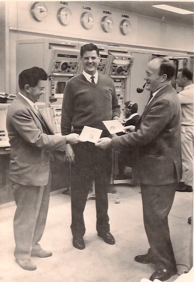
The Prince Charming Award.
Celebrating the successful re-awakening of Surveyor 1 after the long lunar night, Tidbinbilla Station Director Bob Leslie (right) presents “The Prince Charming Award” to Tidbinbilla Ops Supervisor Paddy Johnstone (left) and Hal French, (Hughes) Surveyor Ops Chief.
Paddy sent the command which woke the spacecraft. (There had been a competition to see which station was successful. It was DSS-42 Tidbinbilla!)
Thanks to Hal’s son, Jim French, for the photo.
US Flag landed on the Moon’s surface.
It came to light after the landing that an American flag had been carried to the Moon by Surveyor I. It had been purchased by Sheldon Shallon, Hughes Surveyor Project Chief Scientist, from a SavOn drug store in Los Angeles for 23 cents. After carefully cleaning the flag, Shel had a technician in Florida place it in a structural member of the spacecraft, where it stayed after landing. This caused some concerns with NASA and JPL officials, but since the mission was successful, this did not become a major issue.
_________________
See also:
The Missions: Surveyor 1, Surveyor 2, Surveyor 3, Surveyor 4, Surveyor 5, Surveyor 6, Surveyor 7.
Surveyor Program Results Summary, The Surveyor Spacecraft and Systems.