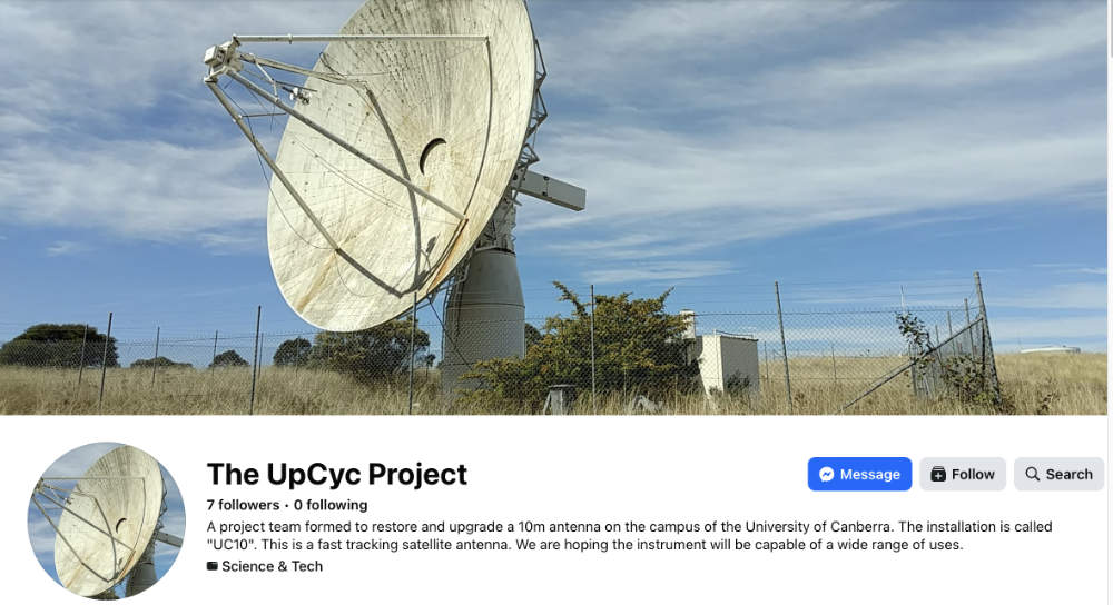
The UpCyc antenna at the University of Canberra.
2025 photo with thanks to Garry Brooke.
The Department of Communications Satellite Monitoring Station
|
The UpCyc antenna at the University of Canberra. 2025 photo with thanks to Garry Brooke. |
The UpCyc antenna
Visitors to the University of Canberra may spot this 10-metre parabolic dish at the NW corner of the campus, close to the intersection of Pantowora and Thirriwirri Streets in Bruce. It is known as the UpCyc antenna, and was used in the 1990s for the monitoring of satellite frequency use.
In more recent times (2025) there are investigations to refurbish it for educational use after around two decades of inactivity –
“The heritage 10m radio telescope on the University of Canberra (UC) campus is a high-quality instrument that was first used in the 1980s in the Orroral Valley and later moved to the university campus.
Falling out of use for science teaching in the early 2000s, its potential has been recently re-imagined by the Faculty of Arts and Design as a resource for diverse community and research arts and science projects.
A project is currently underway to discover how to return it to working order, and investigate how this process can be used to retain the tangible aspects of the telescope, reactivate its intangible heritage of experimentation and innovation, and apply it to modern educational and research needs.” [1.]
The UpCyc Project group have a Facebook page – see this link for their latest updates.
So why was this dish at Orroral Valley in the first place?
In the mid-1980s, the Australian Government’s Department of Communications desired to monitor the frequencies used by satellites visible from the Australian sector.
“In the mid-1980s, the then Department of Communications established a satellite monitoring station at the NASA STADAN site at Orroral Valley… The purpose of the facility was to allow spectrum monitoring of both synchronous (geostationary) and non synchronous satellites.
Information obtained from the spectrum monitoring activities was used to ensure that satellites conformed to the appropriate International Radio Regulations, thereby minimising the chances of interference between satellite and terrestrial radiocommunications services. The facility was in an operational state for some six years.” [2.]
Shortly after the closure of NASA’s Orroral Valley STADAN Tracking Station in 1985, Orroral Valley was chosen as a suitable radio-quiet location close to Canberra. Already in place above the valley was the NATMAP Laser Ranging Station, though the two sites were quite separate. At this point, the tracking station’s buildings were mostly intact, though the NASA antennas had been removed.
Few details seem to have been published about the Satellite Monitoring Station, but it involved the installation of at three parabolic antennae –
a 4.5 metre steerable antenna
a 10 metre all-band (175MHz to 14GHz) fast tracking antenna
a 7-metre antenna.
Where in Orroral Valley was the station located?
A photo from the Department of Transport and Communications Annual Report for 1987-88 shows the 10-metre antenna in front of a distinctive building.
It is the old Minitrack operations building.
 |
This photo of the newly-installed 10 metre antenna was found in the Department of Transport and Communications Annual Report for 1987-88, page 99, by Garry Brooke. |
Checking with satellite imagery of the Orroral Valley site shows the hardstand for the 10m antenna alongside the foundations of the Minitrack building –
 |
Location of the 10m hardstand and the remains of the Minitrack field and Minitrack Ops Building are labelled on this satellite image from Google Maps. North is up. Identification and anotation by Colin Mackellar, 2025. |
 |
This anotated 1966 image shows where the 10m antenna would later be built – once NASA’s Orroral station had closed and the Minitrack antennae were removed. The former Minitrack ops bulding was repurposed for the Satellite Monitoring Station. Photo preserved by Philip Clark. Anotation by Colin Mackellar. |
 |
The later location of the 10m antenna, in what was the Minitrack field, is marked on this 1970 photo. Photo preserved by Philip Clark. Anotation by Colin Mackellar. |
Who ran the station?
While little information is available, it seems that Jeff Newnham, one of the Tidbinbilla originals, held a senior position.
At some point in his career, Jeff worked in Orroral Valley, but apparently not at the STADAN station. The then Department of Communications – where Jeff worked in the late 1980s – established the Satellite Monitoring Station in Orroral Valley after the NASA tracking station had closed in 1985.
Jeff’s family remember him showing them around his facility at the time of the Apollo 11 20th anniversary in July 1989, and this would be consistent with Jeff being in a senior position. (Can anyone shed more light on this? Contact.)
What happened to the station?
By the early 1990s, it was considered impractical to maintain the Satellite Monitoring Station at Orroral – especially as what was left of the NASA station was removed. In 1992, Mr Max Pearce, Projects Director of the Department of Transport and Communications, Radiocommunications Division Laboratory, approached Professor Paul Edwards at the University of Canberra with a proposal to move the Orroral Valley Satellite Monitoring Facilities to the UC campus.
Around 1994, the 4.5m and 10m antennae were thus moved, after negotiations between the then Department of Communications and the Arts and the University of Canberra. The cost of the move was somwehere around $750,000. [2.]
The 4.5 metre antenna (with Ku and C band feeds) was installed on the Information Science and Engineering Building in the south of the campus, and the 10 metre antenna (with two interchangeable feeds – a VHF/UHF cross log-periodic antenna and a 1.5 GHz – 12.75 GHz spiral antenna feed) was relocated to the NW corner of the campus.
In their new positions, both were used for Frequency Management research by the Communications Laboratory of the Department of Communications and the Arts as well as for
The 7 metre antenna was not retained. On 18 May 1994, this advertisement was placed in the Purchasing and Disposals section of the Commonwealth of Australia Gazette –
 |
“Aussales is seeking offers for the ‘as is, where is’ purchase and removal of a containerised 30kVa generator, a 7 metre satellite dish with controller, and a water tank and stand, located at Orroral Valley. …” With thanks to Garry Brooke for the information and link to Trove. |
Plans for a new life for the 10 metre antenna
In 2026, the 10 metre dish is well on the way to having a new life. As an information poster for UpCyc explains,
“The 1980s 10m radio telescope at the University of Canberra was used till 2005 by the Engineering faculty for satellite tracking and communications. Falling foul of university cutbacks it then stood unused, unloved and unmaintained for 20 years.
By the 2020s it was becoming unsafe, but would be hugely expensive to remove. It was a problem looking for a solution.
Enter the Arts and Design faculty. Inspired by the UN Sustainable Development Goals of wellbeing (3), education (4) and sustainable consumption and production (12), Heritage and Creative Arts staff and students began to see a new vision for its future, based on 3 concepts:
• Reduce, Reuse, Upcycle
• An instrument for all interests
• An instrument for everyoneOver the past 8 years a project has evolved to see value in this machine, stabilise it, return it to working order, and create a community to care for it and use it. We think we can do this for under $AUD 200,000, by working with the goodwill and resources in our community. …”
See the full poster below –
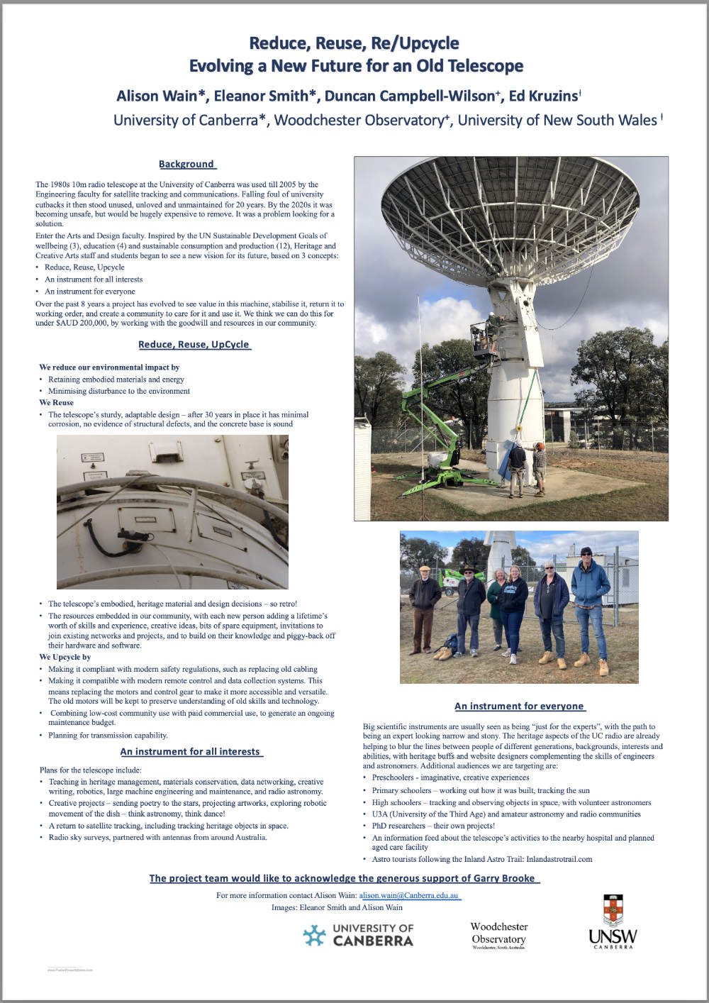 |
Download the UpCyc poster (6.5MB PDF file), with thanks to Garry Brooke. |
The UpCyc team also have a Facebook page – The UpCyc Project – which will be updated from time to time as the project develops.
The original Orroral site today
Along with the Orroral Valley Tracking Station, all that remains today are the concrete foundations, hardstands, roads and tracks, along with interpretative signs.
In February 2025, after the location of the 10m antenna hardstand was determined from satellite imagery, Garry Brooke visited Orroral and shares these ground-level photos –
 |
In February 2025, Garry Brooke visited the site and located the 10m hardstand. This photo is looking roughly north-east. The piers of the Minitrack Ambiguity antenna (?) are visible in the centre distance. The concrete slabs at top left may have been for the 7m and 4.5m Department of Communications antennas. Photo with thanks to Garry Brooke. |
 |
Turning slightly clockwise and looking East, the foundations of the Minitrack Operations Building are visible 40 metres away. Photo with thanks to Garry Brooke. |
 |
This 23 August 1966 photo shows the Minitrack Ambiguity antenna just after completion. The Minitrack operations building is at right. From the Tidbinbilla archives. Scan: Colin Mackellar. |
Thanks to Garry Brooke of the UpCyc Project Team for all his help!
References –
1. University of Canberra website – https://www.canberra.edu.au/research/centres/cccr/cccr-research/research-projects/upcyc.
2. The Joint DCA / University of Canberra Satellite Communications Facility, by P.J. Edwards, et al – from the Proceedings of the Ninth National Space Engineering Symposium 1994. Published by the Institution of Engineers, Australia.