|
A lonely Red Lake Tracking Station stands on Purple Downs Station, about 40km north of Woomera, circa 1961.
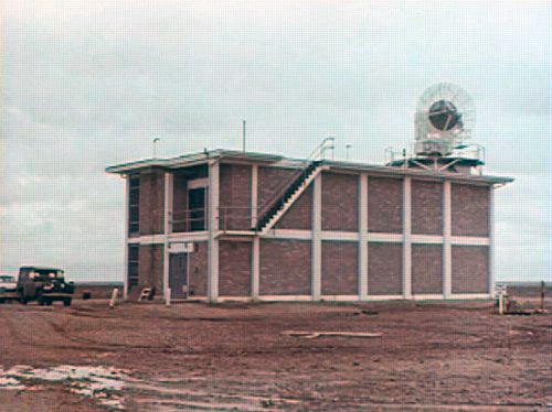
This voew shows the Telemetry and Control Building with its two Telemetry antennas and the Borseight Tower at right. The Range’s FPS-16 Radar would be behind the camera.
Undated transparency D41 from the Tidbinbilla archives.
Scan: Colin Mackellar.
Other photos from this set on the Red Lake Photos page. |
Located 43km north of Woomera, the Red Lake RCA FPS-16
Radar had been built in 1959 by the UK and Australian governments to track Blue
Streak launches from the nearby Woomera Rocket Range. In the preparations
for Project Mercury, an agreement was reached with the US for the FPS-16 to
be used to support Mercury tracking.
It was because of this arrangement that the NASA Telemetry and Acquisition station, with air to ground voice and telemetry, was established at the same location – just 600 metres east of the FPS-16 site.
Tom Reid (later StaDir at Orroral Valley, StaDir at Honeysuckle Creek and StaDir at Tidbinbilla) was the Senior Scientific Officer and Officer in Charge at Red Lake. (He was possibly succeeded by Bill Kaye.)
Warren Berkery, who was a team leader and console operator on the FPS16 tracking radars at Red Lake and Mirikata, says that the Red Lake FPS-16 was also a critical site involved in NASA Project Gemini launches and early project Apollo tests.
In some (later?) photos, there is only the northern Telemetry antenna, and in others additional buildings are present.
 |
 |
The Range FPS-16
Radar. |
The NASA Telemetry station. |
|
|
This NASA
map of the Mercury tracking network shows the ground track for the MA-9 flight.
|
|
A shot of the Red Lake FPS-16 at sunset.
Frame from a NASA documentary on Friendship 7. |


