Apollo 17 Earth Groundtrack charts


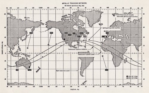
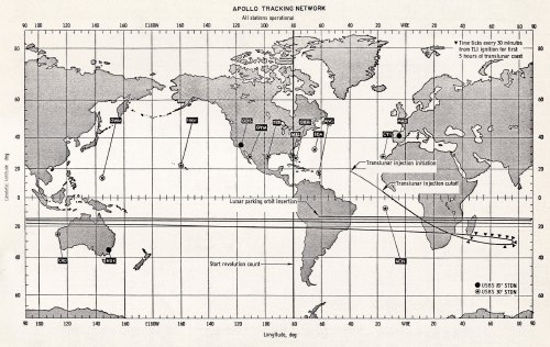
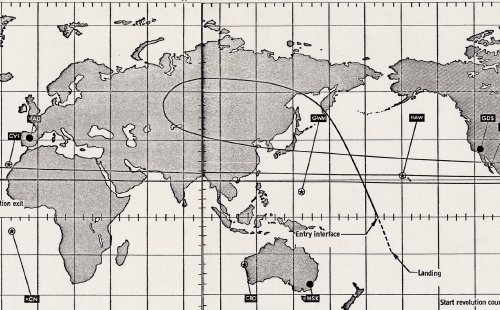
Hamish Lindsay has kept these charts showing the planned groundtracks for Apollo 17 at each stage of the mission.

The GET times on these original pre-mission charts have been omitted since the launch was 2 hours 40 minutes later than scheduled.

The later launch also necessitated an adjusted launch azimuth – hence the planned groundtrack in chart 1 will be a little different from actual.

While not showing the position of the tracking ships or the ARIA, these charts give a very good idea of the spread of the MSFN.

The large version of each of these is around 1.3MB.


Apollo 17 groundtrack

1. The Earth Parking Orbit groundtrack.

Scanned and processed by Hamish Lindsay.


Apollo 17 groundtrack

2. Trans Lunar Coast groundtrack.

Note the time ticks every 30 minutes as Apollo 17 climbs above the Indian Ocean after its TLI burn off the west coast of Africa.

Scanned and processed by Hamish Lindsay.


Apollo 17 groundtrack

3. Trans Earth Coast groundtrack.

The path begins at aquisition as the spacecraft is reaquired after the TEI burn.

Note the ‘foldback’ / ‘groundtrack reversal’ over Central Asia as Apollo 17 accelerates towards Re-entry, three days later.

Scanned and processed by Hamish Lindsay.


Apollo 17 groundtrack

Here is the above chart edited to join the two halves of the ‘foldback’.

(Rough edit: Colin Mackellar.)