Introduction
The Orroral Valley Tracking Station was established as a member of the STADAN
– the Satellite Tracking and Data Acquisition Network as Station 21.
STADAN was concerned
primarily with the tracking of a variety of Earth-orbiting satellites. (The
other initial STADAN stations were at Rosman in North Carolina and Fairbanks
in Alaska.)
The site for the tracking station was selected in 1963, and the land was acquired
early the following year.
|
WRE’s Dick Collins took this 360° panorama of Orroral Valley during an early site visit in 1963.
With thanks to Dick Collins. Dick writes (2012):
“One of my earliest tasks for Lance Sharp (we were both with WRE) was to go to Orroral Valley when it contained absolutely nothing.
Hiding the landrover near the entrance, I walked into the centre armed with a 35 mm camera. Standing there as still as I could I took a number of shots to include the full 360 degree skyline and later cut & joined the prints to form a record of this suitable site for the Stadan station.”
Panorama sssembled by Colin Mackellar in 2012.
Click here to see the full panorama (550kb) – or here to see a 3.8MB version. |
|
Here’s a portion of the panorama, looking East.
On the lower version, the tracking station, as it looked in 1966, has been inserted. |
Bob Leslie writes:
“The land was acquired from Mr Greenfield in April 1964 as notified in the Commonwealth Gazette No. 9 of 30 April 1964. An area of about 40 acres was fenced for the use of the station and the remainder of the land was returned to Mr Greenfield for agistment.
The contract for the construction of the station buildings, power house, antenna foundations, etc., was let by the Department of Works to T.H. O’Connor in August 1964.
Tom Reid became the Station Director of Orroral Valley in August 1964 and EMI Australia, in association with Hunting Engineering, accepted a maintenance and operation contract to support the station in September 1964. Ron Reynolds managed the contract for the consortium and Bill Brear was the contractor senior representative responsible for the task under the contract.”
Orroral Valley became operational in October 1965
and was officially opened in February 1966.
|
Orroral Valley was just across the ridge from Honeysuckle Creek, though by road it was considerably further from Canberra. The Honeysuckle Coll. Tower also served as a relay for Orroral back to Tidbinbilla.
Orroral was built and was operational before Honeysuckle Creek.
Map from a 1976 Department of Science leaflet. |
The station’s main antenna was an 85 foot (26 metre) dish.
As the station’s work grew, the Minitrack station
was moved from Island Lagoon near Woomera to Orroral Valley in 1966.
In 1975,
the Island Lagoon Baker Nunn tracking camera was also brought to Orroral.
A Laser-ranging Geodetic Observatory was also installed,
for the purpose of ranging on the laser reflectors left on the lunar surface
by the Apollo astronauts.
(This was the laser installed and originally operated by the Australian Department of National Mapping. It was located on Mt. Orroral near the 26m antenna collimation tower.
Orroral also had another laser system installed somewhat earlier under the auspices of the Smithsonian Astrophysical Observatory (SAO) of Cambridge, Massachussetts. This laser could track satellites fitted with retro-reflectors out to about 12,000km. The calibration target for this laser was a white roughly painted board fixed to a rock just below the colimation tower.)
|
The Orroral Valley Tracking Station as viewed from near the Honeysuckle
Creek Collimation Tower.
Photo: Ian Hahn. |
|
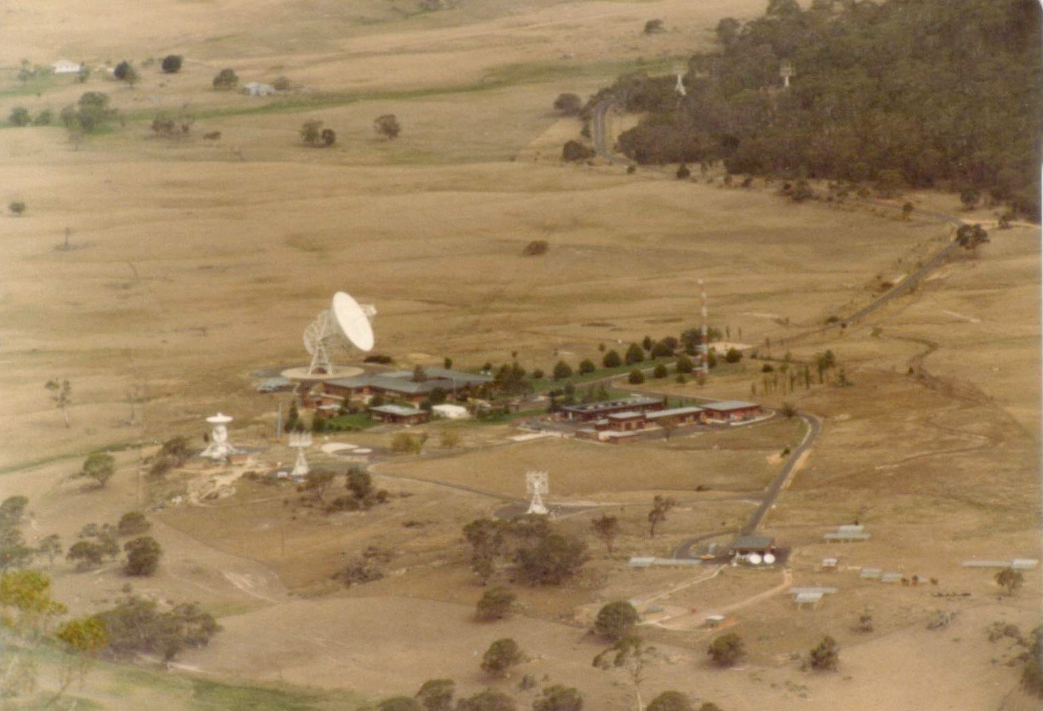
Telephoto shot of the Orroral Valley Tracking Station as viewed from near the Honeysuckle
Creek Collimation Tower.
Photo: Scott Hendry, 1981 or 1982. |
|
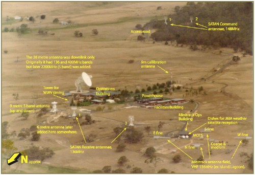
Here’s the same photo as above but with annotations. Click the image for a 2 page PDF file. |
|
|
|
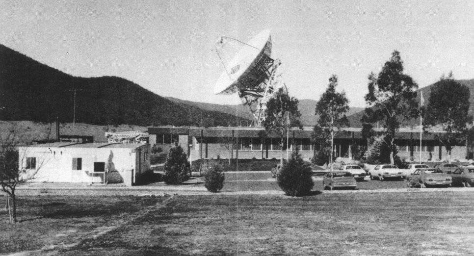
The Orroral Valley Operations Building and 26m antenna.
Photo: Department of Science. |
As well as supporting dozens of Earth-orbiting spacecraft, Orroral tracked the ALSEP packages left on the Lunar surface and also supported the Apollo - Soyuz Test Project and the first Space Shuttle flights.
After Orroral Valley closed in 1985, the 85 foot (26 metre) antenna was relocated to the Mount Pleasant Observatory near Hobart, run by the University of Tasmania. After modification, the antenna is still being used for Radio Astronomy.
Quote from Bob Leslie, from his chapter “Space Tracking Stations”, written for the publication, “Canberra's Engineering Heritage”.